
 bridge crossing, Tolaga Bay, Gisborne District, Gisborne Region, New Zealand (NZ) stock photo.")
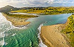
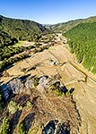
Tolaga Bay township and the Uawa River. Hauiti at left. Aerial view with State Highway 35 (SH35) bridge crossing, Tolaga Bay, Gisborne District, Gisborne Region, New Zealand (NZ), stock photo.
 EMAIL TO FRIEND
- Location:
- Tolaga Bay (other locations)
- District:
- Gisborne (see districts)
- Region:
- Gisborne (see regions)
- Country:
- New Zealand (NZ)
- Notes:
- Large file (8690 x 5793 pixels native, no interpolation). | Ratio (height:width) 1:1.5
- Photographer:
- Rob Suisted
- Image #:
- 63035OP00
Keywords (advanced)
Related images


Similar images


Random images


 bridge crossing, Tolaga Bay, Gisborne District, Gisborne Region, New Zealand (NZ)")