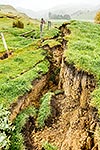
Kekerengu Fault rupture marching across farmland, a strike slip movement of 9 metres, being mapped by GNS scientists. Kaikoura M7.8 earthquake, Tirohanga, Kekerengu, Kaikoura District, Canterbury Region, New Zealand (NZ), stock photo.
These images are protected by copyright, but we license them to suit your needs. Click
'quick quote' to learn more...
Kekerengu Fault rupture marching across farmland, a strike slip movement of 9 metres, being mapped by GNS scientists. Kaikoura M7.8 earthquake, Tirohanga, Kekerengu, Kaikoura District, Canterbury Region, New Zealand (NZ) Stock Photo
Kekerengu Fault rupture marching across farmland, a strike slip movement of 9 metres, being mapped by GNS scientists. Kaikoura M7.8 earthquake, Tirohanga, Kekerengu, Kaikoura District, Canterbury Region, New Zealand (NZ)
 stock photo.")


")