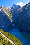
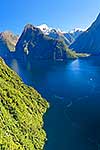
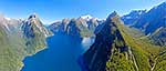
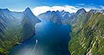
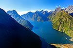
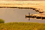
Looking down Milford Sound / Piopiotahi from near entrance. Sinbad Gully and Mitre Peak (1683m) left, The Lion (1302m), Mount Pembroke (2015m) centre, and Harrison Cove and Mills Peak right. Aerial panorama, Milford Sound, Fiordland National Park, Southland District, Southland Region, New Zealand (NZ), stock photo.
These images are protected by copyright, but we license them to suit your needs. Click
'quick quote' to learn more...
Looking down Milford Sound / Piopiotahi from near entrance. Sinbad Gully and Mitre Peak (1683m) left, The Lion (1302m), Mount Pembroke (2015m) centre, and Harrison Cove and Mills Peak right. Aerial panorama, Milford Sound, Fiordland National Park, Southland District, Southland Region, New Zealand (NZ) Stock Photo
Looking down Milford Sound / Piopiotahi from near entrance. Sinbad Gully and Mitre Peak (1683m) left, The Lion (1302m), Mount Pembroke (2015m) centre, and Harrison Cove and Mills Peak right. Aerial panorama, Milford Sound, Fiordland National Park, Southland District, Southland Region, New Zealand (NZ)
 left, The Lion (1302m), Mount Pembroke (2015m) centre, and Harrison Cove and Mills Peak right. Aerial panorama, Milford Sound, Fiordland National Park, Southland District, Southland Region, New Zealand (NZ) stock photo.")

 left, The Lion (1302m), Mount Pembroke (2015m) centre, and Harrison Cove and Mills Peak right. Aerial panorama, Milford Sound, Fiordland National Park, Southland District, Southland Region, New Zealand (NZ)")
