Haast River with Haast township visible on far right. Marks Range left, Browning Range (in cloud) and Selbourne Range far right, Haast, Westland District, West Coast Region, New Zealand (NZ), stock photo.
These images are protected by copyright, but we license them to suit your needs. Click
'quick quote' to learn more...
Haast River with Haast township visible on far right. Marks Range left, Browning Range (in cloud) and Selbourne Range far right, Haast, Westland District, West Coast Region, New Zealand (NZ) Stock Photo
Haast River with Haast township visible on far right. Marks Range left, Browning Range (in cloud) and Selbourne Range far right, Haast, Westland District, West Coast Region, New Zealand (NZ)
 and Selbourne Range far right, Haast, Westland District, West Coast Region, New Zealand (NZ) stock photo.")
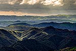
 and Selbourne Range far right, Haast, Westland District, West Coast Region, New Zealand (NZ)")
