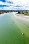
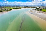
Tamaki River, aerial view past Farm Cove and Wakaaranga Creek towards Point England and Glen Innes. Hauraki Gulf and Rangitoto Island beyond, Pakuranga, Auckland City District, Auckland Region, New Zealand (NZ), stock photo.
These images are protected by copyright, but we license them to suit your needs. Click
'quick quote' to learn more...
Tamaki River, aerial view past Farm Cove and Wakaaranga Creek towards Point England and Glen Innes. Hauraki Gulf and Rangitoto Island beyond, Pakuranga, Auckland City District, Auckland Region, New Zealand (NZ) Stock Photo
Tamaki River, aerial view past Farm Cove and Wakaaranga Creek towards Point England and Glen Innes. Hauraki Gulf and Rangitoto Island beyond, Pakuranga, Auckland City District, Auckland Region, New Zealand (NZ)
 stock photo.")


")