Contents
Browse
Best of...our Favs
People & Places
NZ Landscapes
Wild Wilderness
Outdoor Recreation
Wildlife
Flora
Design Ideas
Textures
Patterns
Panoramas
Random 40
Latest Images
Antarctica
NZ Regions
Northland
Auckland
Waikato
Bay of Plenty
Gisborne-East Coast
Hawke's Bay
Taranaki
Manawatu-Wanganui
Wellington-Wairarapa
Marlborough
Nelson
Tasman
Canterbury
West Coast
Otago
Southland
NZ Sub Antarctic
Antarctica
NZ Districts
About Us
Blog
Lightbox Empty
(0)
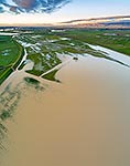
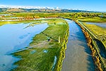
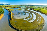
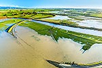
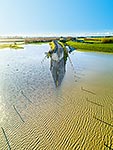
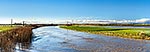
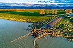
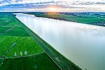
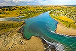
Moutoa Floodway with flooding debris covering Kere Kere Road at southern stop bank. Tararua Ranges beyond. Aerial view, Shannon, Horowhenua District, Manawatu-Wanganui Region, New Zealand (NZ), stock photo.
ADD TO LIGHTBOX
Add to lightbox
Get Quick Quote
EMAIL TO FRIEND
Location:
Shannon
(other locations)
District:
Horowhenua
(see districts)
Region:
Manawatu-Wanganui
(see regions)
Country:
New Zealand (NZ)
Notes:
Large file (5967 x 7956 pixels native, no interpolation. | Ratio (height:width) 1:0.75
Photographer:
Rob Suisted
Image #:
57355EX00
Keywords
(
advanced
)
Environmental
,
Aerial-view
,
Rivers-rivers
,
Dairy-farming
,
Farm-land/pasture
,
Weather-floods
,
Shannon
Horowhenua District
Manawatu-Wanganui Region
Related images
Similar images
work with SIMILARS
Random images
more RANDOM images
These images are protected by copyright, but we license them to suit your needs. Click
'quick quote'
to learn more...
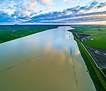
Moutoa Floodway with flooding debris covering Kere Kere Road at southern stop bank. Tararua Ranges beyond. Aerial view, Shannon, Horowhenua District, Manawatu-Wanganui Region, New Zealand (NZ) Stock Photo
Shannon, Horowhenua District, Manawatu-Wanganui Region, New Zealand (NZ)
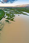
Moutoa Floodway with flooding debris covering Kere Kere Road at southern stop bank. Tararua Ranges beyond. Aerial view, Shannon, Horowhenua District, Manawatu-Wanganui Region, New Zealand (NZ) Stock Photo
Rob Suisted
Moutoa Floodway with flooding debris covering Kere Kere Road at southern stop bank. Tararua Ranges beyond. Aerial view, Shannon, Horowhenua District, Manawatu-Wanganui Region, New Zealand (NZ)
 stock photo.")
")