
 and Freyberg Range at left. Square format, Maruia Springs, Buller District, West Coast Region, New Zealand (NZ) stock photo.")
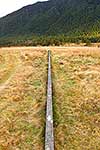
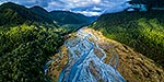
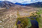
Maruia River flats draining down from Lewis Pass, in breaking weather. Aerial view of braided river flats and beech forest. Mt Mueller (1630m) and Freyberg Range at left. Square format, Maruia Springs, Buller District, West Coast Region, New Zealand (NZ), stock photo.
 EMAIL TO FRIEND
- Location:
- Maruia Springs (other locations)
- District:
- Buller (see districts)
- Region:
- West Coast (see regions)
- Country:
- New Zealand (NZ)
- Notes:
- Very large file (7463 x 7427 pixels native, no interpolation. | Ratio (height:width) 1:1
- Photographer:
- Rob Suisted
- Image #:
- 56923FR00
Keywords (advanced)
Related images


Similar images


Random images


 and Freyberg Range at left. Square format, Maruia Springs, Buller District, West Coast Region, New Zealand (NZ)")