
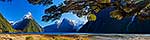
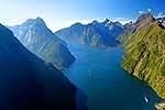
 left, The Lion (1302m), Mount Pembroke (2015m) centre, and Harrison Cove and Mills Peak right. Aerial panorama, Milford Sound, Fiordland National Park, Southland District, Southland Region, New Zealand (NZ) stock photo.")
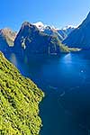
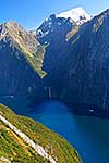
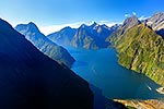
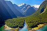
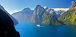
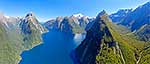
Looking down Milford Sound / Piopiotahi from near head. Sinbad Gully and Mitre Peak (1683m) left, The Lion (1302m), Mount Pembroke (2015m) centre, and Harrison Cove and Mills Peak right. Aerial panorama, Milford Sound, Fiordland National Park, Southland District, Southland Region, New Zealand (NZ), stock photo.
 EMAIL TO FRIEND
- Location:
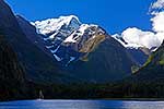
- Milford Sound, Fiordland National Park (other locations)
- District:
- Southland (see districts)
- Region:
- Southland (see regions)
- Country:
- New Zealand (NZ)
- Notes:
- Large digital file (9244 x 4937 pixels native, no interpolation) | Ratio (height:width) 1:1.87
- Photographer:
- Rob Suisted
- Image #:
- 40688OP00
Keywords (advanced)
Related images


Similar images
Random images


 left, The Lion (1302m), Mount Pembroke (2015m) centre, and Harrison Cove and Mills Peak right. Aerial panorama, Milford Sound, Fiordland National Park, Southland District, Southland Region, New Zealand (NZ)")